Milton forecast for Florida hurricane landfall. Cat bond & ILS market on watch
Steve Evans
The Gulf Coast of Florida is facing another hurricane landfall, as tropical storm Milton has formed and is set to head quickly towards Florida, with rapid intensification forecast and a major hurricane Milton landfall possible that could have the potential to cause meaningful insurance and reinsurance market losses.
Tropical storm Milton formed yesterday in the south western Gulf of Mexico and is expected to travel across the warm Gulf waters gaining strength as it heads for a Florida landfall somewhere between Marco Island in the south to Cedar Key north of Tampa, based on a range of forecasts we’ve seen.
However, the GFS and a number of the most widely viewed forecast models have a strong hurricane Milton making landfall near to Tampa Bay, potentially at major Category 3 or greater intensity.
The NHC forecast cone center line is currently focused on Tampa Bay as well, but there is some uncertainty as the cone is relatively wide still at this time. The NHC says “steady to rapid strengthening is forecast during
the next few days,” and Milton could be a major hurricane early this coming week.
It’s worth noting that the forecast path, based on the NHC cone center line, would take Milton’s strongest winds and highest surge into Tampa Bay, affecting one of the most populous regions of Florida, after which inland impacts in areas such as Orlando would be expected, if the current forecast holds.
There remains a good deal of uncertainty, Milton is still a tropical storm after all. But, forecast models are gaining agreement on the rapid intensification to a strong to major hurricane Milton before landfall somewhere on the Florida Gulf Coast on Wednesday or Thursday, with most seemingly opting for a Tampa area landfall, some further south between Sarasota and Cape Coral.
On which basis, it’s already clear this is not looking like another situation where a significant hurricane strikes a low population region of Florida coastline, like the Big Bend, as we’ve seen of late resulting in single-digit billion dollar industry losses.
This is a storm that models suggest is more likely to hit a region with far greater population density and exposure concentration, with the potential to take a path inland over similarly high
concentrations of insured property, raising the spectre of potentially meaningful losses for insurance and reinsurance markets, with possible ramifications for the catastrophe bond and insurance-linked securities (ILS) market.
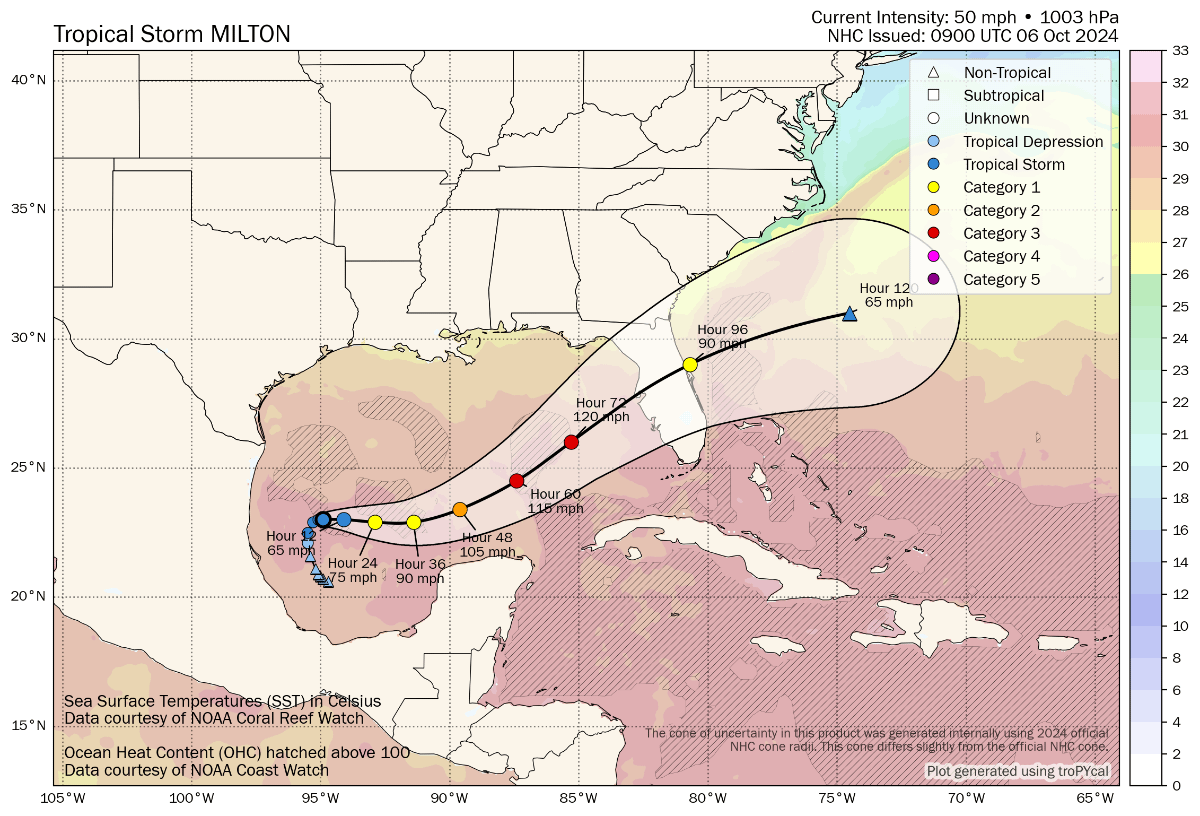
Tropical storm Milton’s latest location and the forecast cone and wind speeds can be seen in the graphic below from Tomer Burg:
The NHC’s forecast advisory suggests sustained winds of around 120 mph prior to landfall with gusts to 150 mph, so major Category ...
CONTINUED